Hiking in Noszvaj
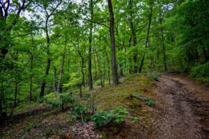
Noszvaj and its surroundings are rich in hiking opportunities. From walks of just a few kilometres to a full day of hardcore hiking, many trails await the nature lovers.
After all that walking, would you like to relax in the hot tub or have a nice foot massage? You don’t have to go far!
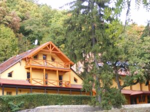
The wellness centre of the Panorama Hotel Noszvaj *** is waiting for you.
After a pleasant soothing rest, you can enjoy your lunch or dinner in a special ambience, in the Panorama Restaurant, surrounded by pine trees.
Are you planning to stay for several days? See our availability.
Download the free “HuMap – Offline EU maps” app from the PlayStore to access the GPS track of the hikes.
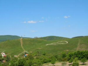
Panorama Hotel Noszvaj *** – De La Motte Castle – artisanal jams – cave dwellings – local wine producers – Imány-tető – cosy confectionery – Reformed church – Panorama Hotel Noszvaj ***
Distance: 6 km, an easy half-day getaway with tasty pastries.
Detailed route description in PDF A látnivalók részletesebb ismertetője.
GPS track: Village walk – Noszvaj
Síkfőkút – Imány-tető – Kerek-domb – Patkó-hegy – Síkfőkút
GPS track: Village detour
Síkfőkút – Attila’s well – Várkút – Kövesdi Lookout – Iron mine – saddle – Novaj hut – Síkfőkút
Distance: 7,3 km with 300m ascent and descent.
Hiking type: easy family hike on well-signposted and marked hiking trails.
Most of the trail provides shade and has 2 water access points. At the Attila Fountain and the Castle Fountain. There are several resting areas with benches. The best ones are at Attila’s Fountain, in front of the tourist house at Várkút and at the Kövesdi lookout. There is a short but winding path to Várkút, the rest of the road is easy to walk. It is also perfect for families with children, with safe, wide forest paths, varied terrain, several rest areas, springs, lookouts and scenic forest views.
Detailed route description in PDF.
GPS track: family route.
Síkfőkút – Várkút – Vár-hegy – Kövesdi Lookout – abandoned dolomite mine – Iron mine – hilltop – Novaj hut – Cseres-tető – Síkfőkút
GPS track: for experienced hikers.
Description of the route in PDF Experienced hikers’ favourite route.
Description of the route in PDF Experienced hikers’ favourite route.
The yellow-marked tourist route (Bükkalja stone road) follows the same route as the mediaeval historical road.
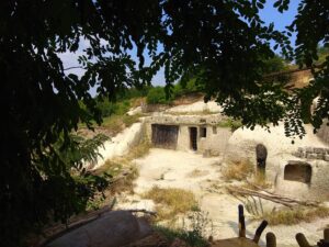
The “Via ad Szomolya” has been used for centuries by chariots, as evidenced by the chariot tracks (“rhyolitic deep road”) cut several metres deep into the rhyolitic tuff. The “Szomolya road” or “Egri road”, was located on the border of the village of Ostoros and an abandoned settlement, Szőllőske. Several cellars, caves and hidden places carved into the rock are scattered around the area, as reminders of the once flourishing vineyard culture, – and the Bükkalja stone culture, which developed on the surface of the rhyolitic tuff.
Details of the trail can be found on the website of the Kaptárkő Natural and Cultural Association.
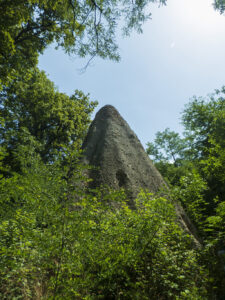
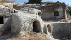
The main stops on the Ördögtorony trail, which connects the interesting and characteristic sights of Bükkalja, are the eponymous, bizarre rhyolite tuff formation, the Ördögtorony (Devil’s Tower), the Suba-lyuk (Suba Hole), famous for its Neanderthal remains, the Little America cave dwellings near Cserépfalu, and the charming Berezdalja wine cellars with the Millenium Monument and lookout designed by György Csete. For more details click here.
Drive to Cserépfalu, then hike to the hive stones in the valley of the Hór! Worth visiting Suba-Lyuk cave, the country house in Oszla, and Ódorvár.
GPS track: for experienced hikers.
Description of the route in PDF Experienced hikers’ favourite route.
The hike starts from Síkfőkút.
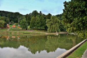
To the north of Noszvaj, lies the valley of the Kánya stream, surrounded by picturesque forests and mountains. This area is represented by Síkfőkút with the landscape of lakes created by nature and later formed artificially, the St. Imre spring and the tourist house built next to it. The tourist and recreational facilities in the area were established in the 1930s on the initiative of the Tourist Association of Eger. With great care and enthusiasm, they developed all the springs of the Kánya stream and its surroundings.
Since the 1930s, Síkfőkút and its surroundings have become a popular tourist destination in the Eger area. The tourist house was built at the same time and has been rebuilt several times since. It was also the time when the first lake was formed to its current shape.
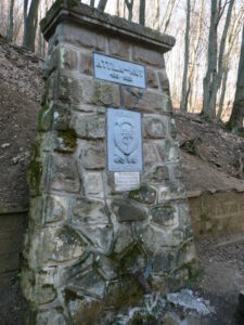
It was the initiative of the Tourist Association of Eger, who with great care and enthusiasm, developed all the springs of the Kánya stream and its surroundings and named them. One of these attractions is the Attila’s Well near Síkfőkút, which has been turned into a forest picnic area.
Várkút is mentioned in old documents from the time of the Tatar invasion.
However, according to archaeological excavations, the hilltop was already inhabited much earlier, in the 3000s BC.
The hilltop was inhabited by an early Stone Age group. This unknown group later disappeared without trace and the hilltop remained uninhabited for a long time, until 900 BC. In the early Iron Age, there was a settlement of log houses surrounded by earth banks and ditches in the area of Vár-kút.
During the excavations, researchers also found traces of settlers here from the post Hungarian Conquest period. At the beginning of the Middle Ages, before the Tatar invasion, there was already a castle standing on the Várhegy next to Eged, Nagy and Kis Tiba hills. It is said that the ancient earthwork castle, built at the beginning of the Árpád era, was a strong defensive line for the archdiocesan-centred town.
Even before the castle was built, Attila’s Well was already well known. This spring is the birthplace of the Kánya stream, which flows down from the hills and joins the Rima and Eger streams on the flatlands, and finally flows into the Tisza.
Before the Tatar invasion, a fortified earthwork castle was built over the spring to protect the city of Eger. The ruins of the castle can still be found today, having recently been completely cleared by the Agria Special Rescue Service, with the help of enthusiastic volunteers from Eger. During the siege of Eger in the Middle Ages, the Turks also caused great devastation destroying almost everything. However, “In the year of our Lord 1552, the defenders of Eger’s famous ramparts” stopped them! The stony road that branches off from road 25, leading out to Várkút and winding through some of the most scenic parts of the Bükk mountain, is still called the Turkish Road.
During the Second World War there were forest battles on Várhegy. Small mine fragments can still be found in the older trees.
In the upper areas behind the tourist house, old German machine gun nests, bomb craters and firing positions can still be found…
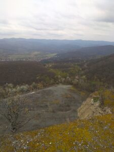
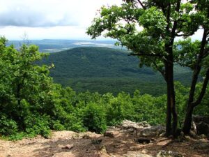
At the Kövesd Lookout point, you can enjoy one of the most beautiful panoramas of the Bükkkalja.
Dolomite mine – Felsőtárkány
The dolomite mine was opened in 1963 and closed in the 1980s.
The mine was responsible for the construction of the Vár-hegy mini-railway line branch of Eger – Felsőtárkány, which was opened in 1969, was due to the mine. The transport of stone ceased in 1985.
Novaj hut serves as a little shelter in case of rain.
Copyright© Panoráma Hotel Noszvaj *** 2023.